S-PASS: Paris Basin – The resources and uses of the urban subsurface
Within the context of climate change and the urbanisation of the Greater Paris region, improving knowledge of the Parisian subsurface, whose space could be used for future developments, and assessing the potential for its use are key issues. The S-PASS project aims to collect and analyse data concerning the subsurface of the Greater Paris metropolitan area in order to improve our knowledge of the latter and share it with citizens and developers, by creating a 3D digital model combining geology, geotechnics and infrastructures. It also aims to assess the possibilities of using the urban subsurface for geothermal energy and recovering building materials.
Ressources et usages du sous-sol
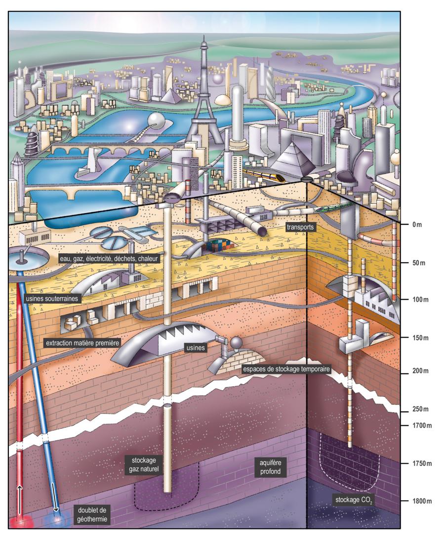
Illustration of a sustainable city © BRGM
Challenges. The subsurface is fundamental to the city’s development and evolution. It is the foundation on which surface developments are built and a place that houses public transport and other networks (water, communications, etc.). It is also a source of energy that is still under-exploited in urban areas: geothermal energy.
Within the context of climate change, whose effects will be particularly noticeable over the next few decades in major metropolitan areas, the subsurface could also be used as a new space to be developed, as an alternative to urban sprawl, whether for tertiary developments (shops, offices, cultural spaces, etc.) or even housing. The S-PASS project – targeted project no. 10 of the “Subsurface: a Common Good” PEPR – addresses these issues within the geographical scope of the Greater Paris Metropolitan area, which extends around the city of Paris as far as the Grand Paris Express driverless-metro project.
It focuses on the first 200 metres of the sub-surface and aims to:
- Provide a better understanding of the geological formations (as well as their associated variability) and the geomechanical properties of the subsurface beneath the heavily urbanised suburbs of Paris, and test new geophysical methods in urban areas;
- Build a 3D digital model combining a 3D geological model of the Cenozoic geological formations, incorporating the natural variability of the formations present, due to the way they were formed, and the existing underground public transport infrastructures. Combining these two models will enable us to create a prototype digital twin of the urban subsurface of the Paris area;
- Make the public aware of these underground spaces and their potential in terms of future developments, while analysing the environmental footprint of the use of the subsurface in the urban development model in comparison to above-ground developments, based on sustainable development indicators;
- Consider innovative methods for increasing circular-economy applications, i.e. recovering excavated earth from underground works and using heat from the underground environment thanks to the creation of infrastructures or geothermal doublets and probes.
Expected results. The results and deliverables of the various sub-projects will be made available through the principle of open science in various formats (scientific publications, palaeogeographic maps, methodological guides, a catalogue of data and geomechanical parameters, a web platform for presenting information and displaying data, a 3D model of the subsurface, etc.).
The specific objectives are to:
- Clarify the environmental relationships between carbonate, marl and evaporitic facies deposits and produce palaeogeographic maps concerning key periods in the evolution of the Paris Basin.
- Provide a generic guide to explain lateral facies variations and the distribution of facies in the basin.
- Produce charts in order to understand the damage caused to the surface by underground work.
- Create a reference guide on the geomechanical parameters of the underground formations in the Paris area for geotechnical engineers. This guidebook will aim to establish a link between the geological facies and the geotechnical parameters.
- Present the new geophysical tools developed (or that could be developed) for observing ground movements and characterising the terrain in urban areas.
- Produce a 3D model of the Parisian subsurface: a tool that summarises and pools all the knowledge available for scientists, spatial planners and engineers. The model will be tailored to the audience and uses concerned, and take into account potential conflicts of interest. It will be simplified for educational purposes and for non-specialist audiences. The 3D model will be the first building block for creating a digital twin of the Greater Paris metro.
- Provide a review of the exchanges between the various players in society and assess the problems of the use of urban subsurface in terms of citizens’ understanding/perception, and in terms of environmental impact.
- Determine whether or not excavated soil can be reused to create fertile soil.
- Specify the geothermal potential of the Greater Paris area and provide guidelines on the sizing of structures and the risks associated with exploiting this resource in relation to infrastructures or geological formations.
Links
- IREX, Ville 10D, Ville d’idées: https://www.ville10d.fr/publications/rapports-ville-10d-ville-didees/
- RGF (Référentiel géologique de la France [French geological repository]), BRGM: https://rgf.brgm.fr/page/bassin-parisien
- RATP : portal of the RATP (Paris Public Transport operator): https://ratpgroup.com/fr/
- Grand Paris Express project: https://www.grandparisexpress.fr/
Project leader : Isabelle Halfon, BRGM et Jocelyn Barbarand, Université Paris-Saclay
Funding : « Sous-sol » Priority Research and Equipment Program (PEPR), funded by France 2030
Staff involved at GEOPS : Benjamin Brigaud, Jean-David Moreau, Pascal Sailhac, Marc Pessel, Cédric Bailly, Emmanuel Léger, Hermann Zeyen, Gaël Monvoisin, Jocelyn Barbarand
Collaboration with
BRGM (établissement coordinateur)
Université Paris Saclay
Université de Lorraine
Université Gustave Eiffel
Université de Lille
CNRS (Délégation Centre Limousin Poitou Charente) – Université de Poitiers
CETU (Centre d’étude des tunnels)
Université Grenoble Alpes
Université de Reims Champagne Ardenne
Ecole Nationale des Ponts et Chaussées
RATP